#surveying #LiDAR #photogrammetry #archeology #UAV #Sulmierzyce #maConcept #Argeos #innovation
Contemporary archeology increasingly relies on modern measuring tools, with surveying and photogrammetry playing a key role in this process. A perfect example of such synergy is our project in Sulmierzyce, where we had the opportunity to support the archaeological work of Argeos with comprehensive field measurements and advanced spatial data processing.
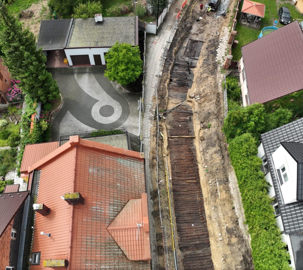
During the archaeological work, an exceptionally well-preserved medieval-modern wooden road [1] was discovered, which functioned from the 14th to the 17th century and connected the market square with the former bridge over the Czarna Woda River. The structure, found over a length of approx. 78 meters, consisted of several layers of pine logs supported by oak piles stabilizing the marshy ground, and its full width could reach up to 8 meters. During the research, numerous artifacts were also found – horseshoes, metal elements, ceramics, a pipe, and a fragment of a leather shoe – which provide insight into the lives of the former inhabitants. Dendrochronological and radiocarbon analyses confirmed that the oldest elements of the road date back to 1364, and the youngest to the period after 1647, making this discovery an extremely valuable testimony to the history of the city. A detailed description of the work and discoveries comes from documentation prepared by Argeos.
Geodesy as the foundation of archaeological research.
Each archaeological site requires precise determination of the location of excavations and finds in space. In Sulmierzyce, we established a geodetic network linked to the national detailed network [2], which became the basis for all measurement documentation. Thanks to this, all elements of the site were clearly defined in the applicable coordinate system, which is crucial both at the research stage and for the subsequent archiving of results.
The geodetic network served as a stable reference frame for:
- photogrammetric fitting points,
- subsequent stages of field measurements,
- integration of data from drone flights and lidar point clouds.
Photogrammetry and LiDAR – digital documentation of the open pit. [3]
As part of the project, we used unmanned aerial vehicles (UAVs), which enabled fast and non-invasive data acquisition. [4]
The flights were performed using a DJI Matrice 350 RTK drone with a DJI LiDAR Zenmuse L2 sensor, at an altitude of 25 meters, using the oblique function.
We carried out two types of flights:
- vertical – providing high-quality material for the development of an orthophotomap,
- oblique (45°) – allowing for accurate mapping of the open pit and its edges and obtaining a richer point cloud.
This combination of photogrammetry and LiDAR technology made it possible to obtain a complete spatial image of the archaeological site, while preserving details relevant to scientific documentation.
Repeatability of measurements and change control.
The specific nature of archaeological work requires the documentation of successive stages of exploration. Therefore, we carried out two flights, each time setting up 10 photogrammetric targets, precisely referenced to the geodetic grid.
This allowed us to:
- compare changes over time,
- analyze the progress of work,
- maintain data consistency at different stages of research.
As a result, archaeologists received not only a picture of the “state of affairs on a given day,” but also a tool for analyzing the processes taking place during the research.
Results of the work – modern tools for archaeology.
The final results of the project in Sulmierzyce were:
- an orthophotomap [5] compiled on the basis of two aerial surveys,
- a three-dimensional 3D mesh model of the entire archaeological site.
These materials provide valuable support for further analysis, conservation documentation, and presentation of research results. What is more, the digital form of the studies allows for their archiving and repeated use without the need to re-enter the site.
Geodetic documentation, photogrammetry, and LiDAR played a key role in the precise preservation of this unique relic of infrastructure.
Geodesy and archaeology – a shared future.
The project in Sulmierzyce shows that surveying is now an integral part of modern archaeological research. Precise measurements, modern UAV and LiDAR technologies, and reliable data processing allow us to effectively combine the world of science with measurement engineering, creating lasting and valuable documentation of cultural heritage.
If you are looking for a partner who combines precision with technology and experience with innovation, we invite you to cooperate with us.
[1] https://www.facebook.com/photo/?fbid=1086699020266484&set=a.404042608532132
[3] https://www.youtube.com/watch?v=fpgerZufA4Q
[4] https://sigma-not.pl/publikacja-103763-skanowanie-z-drona-przeglad-geodezyjny-2017-2.html
[5] https://maconcept.org/ortofotomapa-produktem-pracy-geodety/